 ©
©| Home | |
| Intro | |
| 3D & more | |
| Modular | |
| OpenSource | |
| Programming | |
| Download | |
| Cooperation | |
Modular |
MO2Geo
is
planned to become a tool that consists of modules. These modules
shall be able to save, visualize, analyze and model geological data.
This shall be managed by a differentiation on several levels piled
up modularly and being connected by defined interfaces. Visualisation
tools can thus be used for diverse datasets and on different levels.
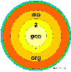
The levels are constructed so that
All models are gathered like shells around
the field data as a core module. Core modules are used to save
the spatial entities, e.g. points (0D, singular measurements),
lines (1D and 1.5D, quasi-continuous data as logs or profiles),
polygons (2D and 2.5D, e.g. geological maps or vertical cuts in
quarries) and volumes (3D, e.g. from the geophysical exploration).
These dataset go far beyond the needs of geographical datasets
but it should be possible to connect them to a GIS, e.g. GRASS.
The second level should be used for the geological description and first interpretation, e.g. principal geology (lithology, genesis, stratigraphy), structural geology and tectonics, hydrogeology, engineering geology, mineralogy, geophysics. The analysis and interpretation of data follows on the third level: uni- and multivariate analysis methods, geostatistical tools, multispecies- and multiphase diagrams, cross sections etc.
The fourth level of the modules: Dynamic modelling tools for sedimentology,
tectonics, hydrogeology, environmental geology and engineering geology
etc. The list of models can be long - it depends on participation
at the project.
|